

Climate Change
Climate Change
The impact of climate change and the likelihood of more frequent and more severe weather presents an ever-greater challenge for every part of society.
This summer, the UK experienced record temperatures of 40.3C and six separate heatwave periods. The hottest ever day was recorded in North Wales in July 2022.
The impacts of a changing climate will be felt first — and most dramatically — through our rivers and water resources. There is the potential for disaster at both ends of the scale: predictions suggest than the frequency and severity of both flooding and droughts will increase as our climate continues to heat up and weather patterns change.
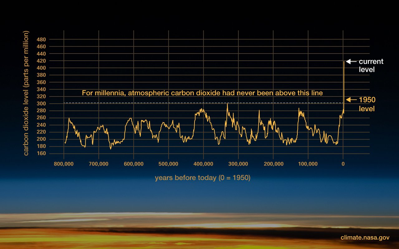
Climate change has been at the forefront of environmental news with global temperature expected to increase by 1.5°C since pre industrial levels (IPCC). With an increase in temperature, sea levels have already increased by 104mm since 1994 according to Nasa.
Climate change also brings an increase in extreme weather such as flooding and drought both have been in the UK news in the last few years. With the climate changing, North Wales’s infrastructure is under more pressure than ever to mitigate the changes.
In September 2022, Natural Resources Wales officers considered the effects of the rainfall on our waters and the local environment and stated there were significant concerns for the ecosystems and habitats, water supplies, land management and agriculture around the Anglesey, Dee and Clwyd catchments. Declaring a drought in these areas.

Rainfall
North Wales is well known for its high annual rainfall being surrounded by mountains and exposed to the prevailing South Westerly wind.
However, the average annual rainfall has been increasing as reflected by figure 2. The average annual flow in some rivers has generally been increasing since 1982 such as the Dyfi and Teifi.
This indicates higher risk of flooding in addition to more material being passed into the Menai Strait. Generally the wettest season is winter. As can be seen by figure 1, the average rainfall intensity in the UK has increased since 1960.
Consequently, CSO’s are under increasing pressure caused by the high intensity rainfall in a short period. The number of impermeable surfaces in the Menai Strait catchment has increased by 2.6% in the last 20 years according to CORINE Land Cover (CLC) Consequently, more impermeable surfaces reduces the lag time and infiltration of water causing extra pressure on an already-strained sewage system that leads into the Menai Straits.


Flooding
New flood maps (pictured) show the potential devastating impacts, rising water levels may have on parts of North Wales. By 2050, towns including Rhyl, Prestatyn and Llandudno, could be submerged by floods, if sea levels continue to rise. According to flood prediction maps. for the UK, by Climate Central, other areas flooded could include parts of south west Anglesey, Queensferry, Flintshire and Porthmadog.
As 13 rivers drain directly into the Strait ( a confined space) we believe that the banks of the Strait may also be at risk of flooding and coastal erosion. The second map shows that rivers entering the Strait are at risk of flooding.
Urban development is increasing the amount of impermeable surfaces. As a result, water runs off of the concrete structures, sometime known as pluvial flooding or urban flooding. In urban areas, with rapid increase in impermeable surfaces and urban development, such as Bangor the likelihood of flooding has increased.
Similarly, the intensity of urban floods becomes higher with prolonged rainfall.
Solutions include slowing the flow upstream, increasing SUDS and rainfall gardens and increasing planting such as alder trees to stabilise banks and reduce sediment run off and the creation of wetland areas.


Seasons
Seasons have a huge impact on the rainfall and consequently coliforms in the Menai Strait. As can be seen by figure 3, there are more fecal coliforms in Winter and Autumn. When this is compared to annual rainfall data there is a clear link between rainfall and coliforms as there is a higher number of rainy days over winter. This suggests that rainfall has a large impact on the number of fecal coliforms detected in the Menai Strait due to agricultural run off, septic tanks leeching and CSO spills.


Drought and warming waters
Although drought occurs naturally when temperatures rise and rainfall drops, climate change and population growth have placed a massive strain on freshwater resources through exacerbating water scarcity.
Water is being abstracted from rivers and the aquifers that feed them at an unsustainable rate, whilst changing rainfall patterns mean that many of our rivers will see a marked decline in flow. When water levels drop, the concentration of pollutants increases, temperatures rise and the freshwater ecosystem suffers.
When water is excessively abstracted from rivers, it can have dire consequences. Unfortunately, many rivers contain pollutants as a result of agriculture, industry and household waste. When water levels drop, the concentration of these pollutants increases—often to a higher level than wildlife and plants can tolerate. Water scarcity also decreases the concentration of oxygen in the water, which again spells disaster for flora and fauna, Low water levels also prevent certain species of fish from migrating, which can completely disrupt important stages of their lifecycle.
We are lucky enough to have clean, running water in our homes—but wildlife doesn’t have this luxury! Many rely on rivers for their water intake, so when rivers dry up, it can cause wildlife to suffer and threatens ecosystems.